Greenfields exploration project available for option in the world class Timmins gold camp
This 94 square kilometre (36 square mile) property is located nine kilometers (5.6 miles) northeast of Newmont-Goldcorp’s multi-million-ounce Hoyle Pond deposit in the Timmins gold camp, northeast Ontario.
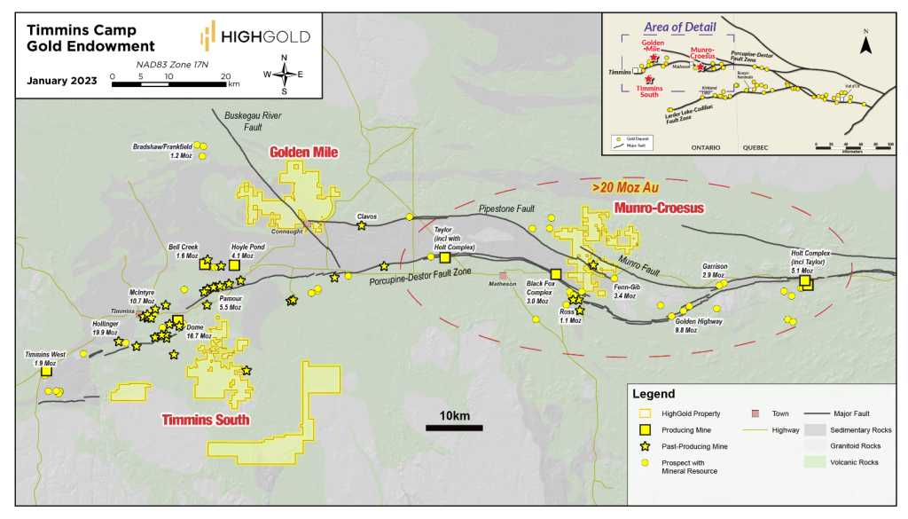
The property covers the extension of the Pipestone Fault System on the north margin of the Timmins gold camp that has produced more than 55 million ounces of gold to date.
Snapshot
| Location | Timmins, Ontario, Canada |
| Ownership | 100% |
| Status | Available for option |
| Deposit Type | Orogenic gold |
| Property Size | 94 square kilometers (36 square miles) |
| Structural Break | Pipestone Fault (past production of 55 Moz) |
| Host Rock | Ultramafic volcanics in contact with a graphitic shear zone and pyritic argillite |
| Age | Precambrian (Neoarchean) |
| Main Economic Elements | Gold |
Location Map
Overview
- The Golden Mile property is located on a major flexure of the important Pipestone Fault System where it crosses the “Porcupine Giant Mine Corridor” that has produced more than 55 million ounces of gold.
- Neighboring gold deposits on the north sediment contact/Pipestone Fault include Fenn-Gib (3.4 Moz), Clavos (+300Koz - 6 km to the east), Bradshaw (+1 Moz) and Lake Shore’s (Tahoe) Timmins West deposit (+1.9 Moz).
History
- Relatively unexplored portion of a major structural break within the Timmins Gold Camp.
Geology
- An overburden-covered structural intersection which contains excellent targets within the thick, folded and faulted ultramafic, mafic volcanic rocks and adjacent Porcupine sediments – a setting common to many Timmins Camp deposits.
Exploration
- This project hosts a strong gold/arsenic anomaly in overburden till samples and la arge Lead-Silver-Nickel MMI (mobile metal ions) soil anomaly
- A five-hole (1,182 meter) drill program was completed in 2014; two holes intersected a graphitic shear zone at the deformed unconformity between carbonate altered komatiites and Porcupine sediments (Timmins West Mine setting) along the interpreted Pipestone Fault.
- A four-hole (1,179 meter) drill progam in 2020 successfully intersected the Pipestone Fault, yielding anomalous gold values, associated gold pathfinder geochemistry and veining in permissive rock units known to be important hosts for gold mineralization within the Timmins Camp. The know strike length of the Pipestone Fault on the project has now increased from 600 meters to over 2000 meters.
- Airborne magnetic/electromagnetic surveys have identified prominent structural breaks and multiple areas for drill targeting
- An 85-kilometer overwater seismic survey was completed in 2022 on Frederickhouse Lake to map the depth of the sediment and bedrock to aid dril planning and interpretation of bedrock geology and structures. Frederickhouse Lake is a large, shallow (2-4 meters deep on average) man-made lake covering the interpreted structural intersection of the Pipeston Fault and the Porcupine Giant Mine Corridor.
Status
- Seeking earn-in Joint Venture partnerships for follow-up on the successful 2020 drill program